Here in Northeast Florida, racist road builders skipped any access to West Augustine from I-95 while destroying Jacksonville's thriving LaVilla community.
Here in St. Augustine, Realtors refused to sell property to African-American buyers (even for cash in 2004 from a Justice Department retiree, who in 2008 was elected to County Commission (J. Kenneth Bryan). And white police officers under the ancien régime once quizzed residents about why they were living or visiting Lincolnville.
Ending redlining resonates with me. I was so proud when my father was told by NAACP that he was the only Realtor in South Jersey who would show a home in West Berlin, N.J., to an African-American couple. I treasure the day in 1977 when my friend, Ed McElwain, and I watched the U.S. Senate pass the Community Reinvestment Act (Proximire Amendment) by one vote in 1977 as a 20 and 22 year old legislative research assistants making recommendations on housing policy to Democratic Senators Jim Sasser and Gary Hart, respectively.
The amendment passed.
By one vote.
Decisions are made by people who show up.
It’s a little after 3pm in Detroit’s 8 Mile neighbourhood, and the cicadas are buzzing loudly in the trees. Children weave down the pavements on bicycles, while a pickup basketball game gets under way in a nearby park. The sky is a deep blue with only a hint of an approaching thunderstorm – in other words, a muggy, typical summer Sunday in Michigan’s largest city.
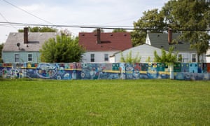
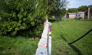
“8 Mile”, as the locals call it, is far from the much-touted economic “renaissance” taking place in Detroit’s centre. Tax delinquency and debt are still major issues, as they are in most places in the city. Crime and blight exist side by side with carefully trimmed hedgerows and mowed lawns, a patchwork that changes from block to block. In many ways it resembles every other blighted neighbourhood in the city – but with one significant difference. Hidden behind the oak-lined streets is an insidious piece of history that most Detroiters, let alone Americans, don’t even know exists: a half mile-long, 5ft tall concrete barrier that locals simply call “the wall”.
“Growing up, we didn’t know what that wall was for,” says Teresa Moon, president of the 8 Mile Community Organization. “It used to be a rite of passage to walk on top of the wall, like a balancing beam. You know, just kids having fun, that kind of thing. It was only later when I found out what it was for, and when I realised the audacity that they had to build it.”
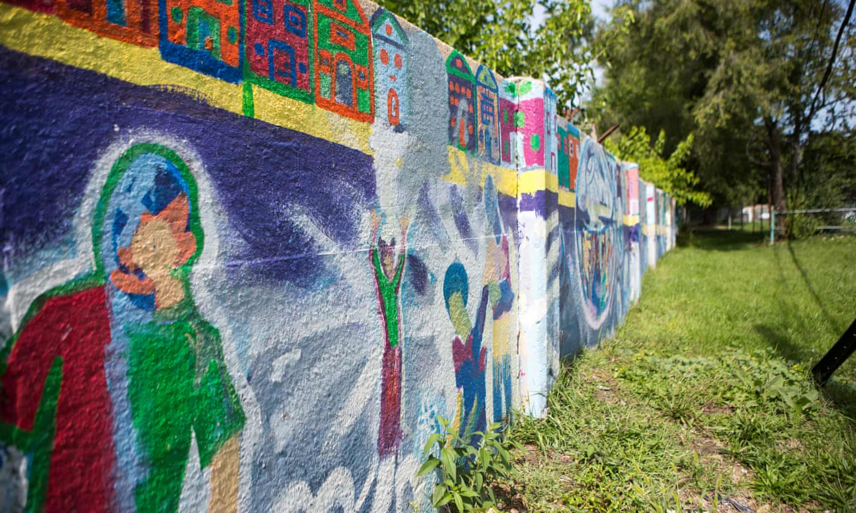
- The wall, a concrete barrier in 8 Mile, Detroit, built to divide black and white neighbourhoods
In 1942, 8 Mile was a black neighbourhood – segregated by law, segregated by culture, segregated from white Oakland County by the eponymous 8 Mile Road. It was a self-contained community, filled with not only African Americans but immigrants of all colours, some of whom had built their houses with their own hands.
It was also adjacent to empty land – valuable land that developers were rapaciously turning into homes for a surging postwar population. Land that one housing developer wanted to use to build a “whites-only neighbourhood”. The only problem was, he couldn’t get federal funding to develop the land unless he could prove he had a strategy to prevent black people and white people from mixing. His answer: wall off the white neighbourhood with a concrete barrier.
“That wall is a monument,” says Moon. “We survived it. It’s a part of what happened, and no one feels any negativity towards what happened.”
Her neighbour, Lou Ross, agrees. “What that Wall was intended for, it didn’t work that way. It did for a minute – but it didn’t last.”
Today, policymakers are making plans to revamp the nation’s infrastructure. The Trump administration has pledged to create a $1tn infrastructure renewal plan, and came to power, after all, on the promise of building a massive wall. But, like Trump’s wall and the 8-mile wall, infrastructure is not value-free – and the decisions made now will affect the future of inequality in our cities.
‘White roads through black bedrooms’

To get an understanding of how infrastructure transforms communities, there’s no better place to start than the Federal Housing Authority “redlining” housing maps. Commissioned by the federal government in the 1930s, these maps were critical to decisions of where and what type of infrastructure, lending and housing each neighbourhood of each American city would be able to receive.
“The FHA promoted home ownership in new – and primarily suburban – neighbourhoods so long as they were white and not ethnically or economically diverse,” writes Antero Pietila in Not in My Neighbourhood: How Bigotry Shaped a Great American City.
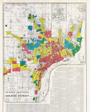
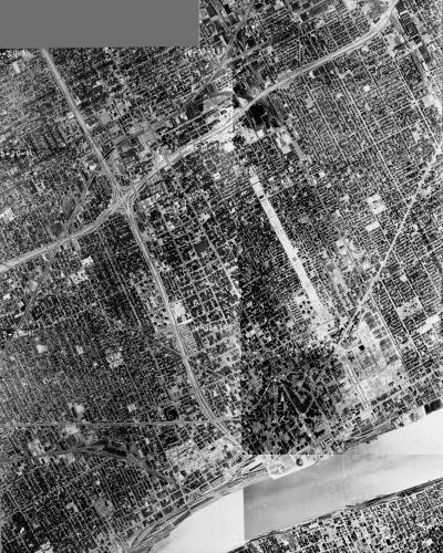
- Left, an FHA Housing Map for Detroit circa 1939, with the 8 Mile neighbourhood clearly ‘redlined’; right, an aerial photomosaic of the city in 1961, showing the completed I-94 and Route 10
If your neighbourhood had the misfortune to be “redlined”, it was often doomed to a future of stillborn investment and decay. Specifically, it would be impossible to secure federally backed mortgages, a sort of scarlet letter branded across huge swaths of the city. Developers avoided these areas and concentrated investment into white areas, and services stagnated. The seeds of the future ghettos of America had been sown.
FHA maps were created for every major city in the US. Original assessment documents unearthed by researchers at the T-Races project reveal the cold, casually racist way in which data collectors consigned vast neighbourhoods to neglect and poverty:

- The I-980 and I-880 merge in West Oakland, California
West Oakland in California is a typical example of a redlined neighbourhood. Historically a working-class community of immigrants and African Americans, it stagnated after being redlined. By the 1950s and 60s, during the interstate building boom, West Oakland was in a prime position to be carved up and paved over: full of low-income housing, it offered little to no political opposition. A literal ring of concrete was poured around the neighbourhood, the precursors to today’s I-580, I-880 and I-980, and the result was decay, pollution and crime that characterised West Oakland for decades. But it was by no means alone. The process of routing roads through black communities was so common it even had a name among critics: “White roads through black bedrooms.”
Baltimore’s ‘road to nowhere’

Nowhere is infrastructure so obviously divisive as with the vast interstate highway system. Ubiquitous, generally free and heavily used, it’s undeniably a vital part of the American experience. There are more than one million miles of federal aid highways in the US, which cost $105bn a year to maintain. If American highway spending were a country, it would have the world’s 63rd largest GDP, just behind Morocco. But while these roads unify and connect millions of the country’s citizens, they’ve also excluded and destroyed many black communities.
West Baltimore is an exceptionally bleak area in an exceptionally poor, overwhelmingly black American city. The city recorded 343 homicides in 2017, the highest murder rate per capita in the country. It’s almost double that of Chicago, and 18 times higher than New York City. Racial divisions run deep here, a segregation of opportunity, class and even life expectancy.
On a humid September morning, police cars darted furiously through empty streets, their sirens blaring. In front of the housing complex where Freddie Gray was killed in 2015, two white police officers questioned a young black man in an SUV, their hands resting on their weapons. Many of the homes have boarded-up windows and doors, and even wooden scaffolding to prevent them from collapsing. The city has more than 16,000 abandoned properties, some of them vacant for decades.

- Abandoned properties dot West Baltimore in a patchwork of blight
In the middle of this blight stands a monument to failed American city planning: a giant ditch that bisects West Baltimore neatly into north and south. Officially named State Route 40, it was originally intended to be a key part of a proposed east-west freeway presented as crucial to the city’s growth. This gigantic project upended hundreds of lives, transformed an entire landscape and cost tens of millions of dollars. The locals call it the “road to nowhere”.
“It was an obvious name to give,” says Denise Johnson, a community organiser who grew up in West Baltimore. “We lost families, we lost homeowners, we lost businesses, and we lost churches. And we lost people. People who were stable. People who didn’t plan to leave the community.”
In the 1950s, a vast increase in cars was beginning to clog the roads to and from the new suburbs. The federal government poured money into the brand new interstate system, encouraging radials, arteries and thoroughfares through dense urban neighbourhoods. This also presented city planners with what seemed an unprecedented opportunity – to use federal funds to clear out “slums” and open up vast tracts of land.

- A view of Baltimore’s freeways, with the ‘road to nowhere’ visible in the centre
Where to build a freeway became not only an economic decision, but also a moral one – a chance to uplift and sweep clean America’s ghettos.
But were they ghettos?
“This was not a neighbourhood that was struggling,” says John Bullock, the city councilman for Baltimore’s ninth district, which includes the road to nowhere. “We’re talking about middle-class neighbourhoods, which were seen through the eyes of others as slums or ghettos because of the colour of the people who lived there.”
The road, says Bullock, who also teaches political science at Towson University, was yet another example of infrastructure marginalising black citizens. “We’re talking about generations of black people who have faced these challenges. Not only from the highway, but also disinvestment, the redlining, the lack of employment. Because if we say housing was lost, churches were lost, we have to remember also businesses were lost. And oftentimes people have to go outside their communities to spend that money, which never gets recirculated in that community.”

- ‘Generations of black people have faced these challenges’ … an aerial shot of West Baltimore
Moreover, while the freeways opened up routes from the suburbs to the city centres, there were often a conspicuous lack of entrances in black communities. The gigantic concrete ditch in West Baltimore is a perfect example: sunken, without exits – it effectively seals off one side from the other.
Interstates touched the lives of millions of people, in hundreds of cities across the US. From Atlanta to Chicago, Denver to New York, black communities felt the twin pain of urban decay and expropriation of land. But before the Voting Rights Act, black people had no legal recourse through which to oppose such plans.
“I call it the falseness of community engagement,” says Denise Johnson, her voice rising with emotion at the frustration of decades of failed promises. “Back then, when they were building that highway, there was no mandated policy that you had to engage the community. Now, there is a mandated policy to engage the community, which is a good thing. But at the same time, it’s still just … their agenda.”

- Abandoned properties in Baltimore’s Oliver neighbourhood
In recent years those failed promises have included the Red Line. This was a light rail project, heavily championed by the city council, that would have connected East and West Baltimore, and provided thousands of jobs and economic development. The proposed route of the Red Line would have been overlaid on the road to nowhere, with a stop at Harlem Park in West Baltimore. But despite the project winning federal approval and funding, incoming governor Larry Hogan cancelled the project, citing its cost, enraging the city government and large portions of the African American community.
In Baltimore, the added insult was that the road to nowhere didn’t even have to happen. To this day, the one-mile, six-lane road sees so little traffic that when it is shut down, as it is occasionally due to film shoots or snowfall, hardly anyone notices. It ends abruptly just outside the city, a strange amputation that is now a park-and-ride, cleaving a terrible wound through the middle of a major city for no reason: too big to replace, too expensive to tear down.
Detroit: the death of Black Bottom

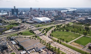
Detroit, like Baltimore, also suffered disruptive interstate projects that decimated African American communities. Submerged highways snake through the city: I-94, I-96, I-75. Home to the automobile, it may be the best connected city in America for cars. Above these transportation corridors, the ghost factories of Ford, General Motors and Chrysler dot a desolate landscape that resembles an urban prairie.
One such district teeming with available land is the historically African American neighbourhood that used to be known as Black Bottom. It was a vibrant, dense area in a prime location just north-east of downtown, with a nationally renowned music scene and home to many famous residents, including boxer Joe Louis and the first African American mayor of Detroit, Coleman Young. The area was mixed, rich and poor, with migrants from Syria, Poland and Germany co-existing in a bustling urban area that ran from the Detroit river all the way up to Grand Ave. Young called it a “thrilling convergence of people, a wonderfully versatile and self-contained society”.
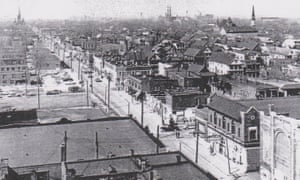
- Hastings Street used to be the main thoroughfare in the Detroit neighbourhood of Black Bottom; an aerial shot of the area today
By the mid-1950s, however, the declining auto industry had hit Black Bottom hard, and the all-white Detroit city council deemed it a “slum”. The neighbourhood became one of the first casualties in the grand “Detroit Plan”. Freeways, hospitals, universities and housing developments were planned and built, creating radical changes to the city fabric, including the destruction of vast amounts of housing to construct Route 10 and I-75.
While some improvements were applauded and created highly valuable land, like Lafayette Park, almost all of the beneficiaries of the improved housing stock were white. Tens of thousands of African Americans were either forced into high-rent properties or high-rise public housing projects. Moreover, white landowners often prevented African Americans from renting in “white communities”. The forced removals of the 1950s remain one of the single biggest upheavals in the city’s modern history.
Today, Black Bottom is gone. All that remains are some vacant industrial buildings, empty fields and I-75.
Jackson Ward: the ‘black Wall Street’

In Jackson Ward, a neighbourhood in Richmond, Virginia, the story was much the same. Formed after the civil war by urban African Americans and recently freed slaves, it was an unlikely place for a vibrant black community (the city was the capital of the briefly lived Confederate States of America).
But vibrant it was. The business community there was known as “black Wall Street” and its social and economic capital earned it the nickname the “Harlem of the South”. Maggie Walker, the first female bank president (of any race) to charter a bank in the US, lived there; a statue of her welcomes visitors to the Ward today. The area was central to the civil rights movement in Richmond and today is honoured with US National Park Service historic status.
Jackson Ward began to change, however, during the second world war. The construction of Gilpin Court, a large public housing project, and the I-95, a transport artery to connect Richmond to its neighbours, saw federal funds pour in. Unsurprisingly, the formerly redlined, historically important neighbourhood of Jackson Ward was chosen as the path of construction.

- A shot of the I-95 in Jackson Ward, showing the road bending around the Sixth Mount Zion Baptist Church
Photographs show the breadth of the interstate – almost a city block wide. The southern section was fortunate in its proximity to downtown, and parts of it are now a sought-after neighbourhood. But the northern section, anchored by Gilpin Court and the Shockoe Hill cemetery, were isolated. Roads, businesses and homes were demolished, turning Gilpin Court into an island. The area plunged into an economic and cultural malaise, disintegrating into blocks of land now filled only with grass.
One small victory was the Sixth Mount Zion Baptist church, a historic site of worship built in 1884, which had the misfortune to be located directly in the path of the interstate. With the bulldozers looming, a loud and furious resistance from community members prevented construction proceeding as planned. The church was permitted to stand, and the entire interstate was re-engineered to bendaround it – one of the few symbols of resistance still visible.
Today, northern Jackson Ward is still 96% African American, and the average income is only $9,357, far below the poverty line of $15,000.
The future

Making the case that infrastructure itself can be exclusionary is hardly straightforward. Many of the worst decisions in US planning were made decades ago to intentionally disenfranchise, marginalise and separate communities; policies such as redlining and “blight clearing” are well-documented embarrassments. But many decisions that segregated communities were unintentional. The stop sign and one-way street might seem benign, but they shape our lives in ways we sometimes don’t even realise.
Roads, bridges and walls are agents of change, with a direct impact on our lives. Who has control over where these are placed? Who says how many there will be? How big? As the US gears up for its biggest infrastructure revitalisation project in decades, it is only by asking these questions and acknowledging the power of city planning to impact lives that we can hope to prevent the injustices of the past and fix those of the present.
Johnny Miller is the founder of the NGO africanDRONE. This story was produced in part with a travel grant and technology support from Code for Africa and from the International Center for Journalists
Follow Guardian Cities on Twitter, Facebook and Instagram to join the discussion, and explore our archive here
No comments:
Post a Comment