Hurricane Dorian's Track Shifts But Florida Still at Risk; Growing Threat For Georgia and the Carolinas
By weather.com meteorologists
less than an hour ago
weather.com
01:31
Important Changes in Forecast for Hurricane Dorian
The latest forecast for Hurricane Dorian is showing the storm moving a bit more north than earlier forecasts.
At a Glance
- Dorian is a Category 4 major hurricane moving through the western Atlantic Ocean.
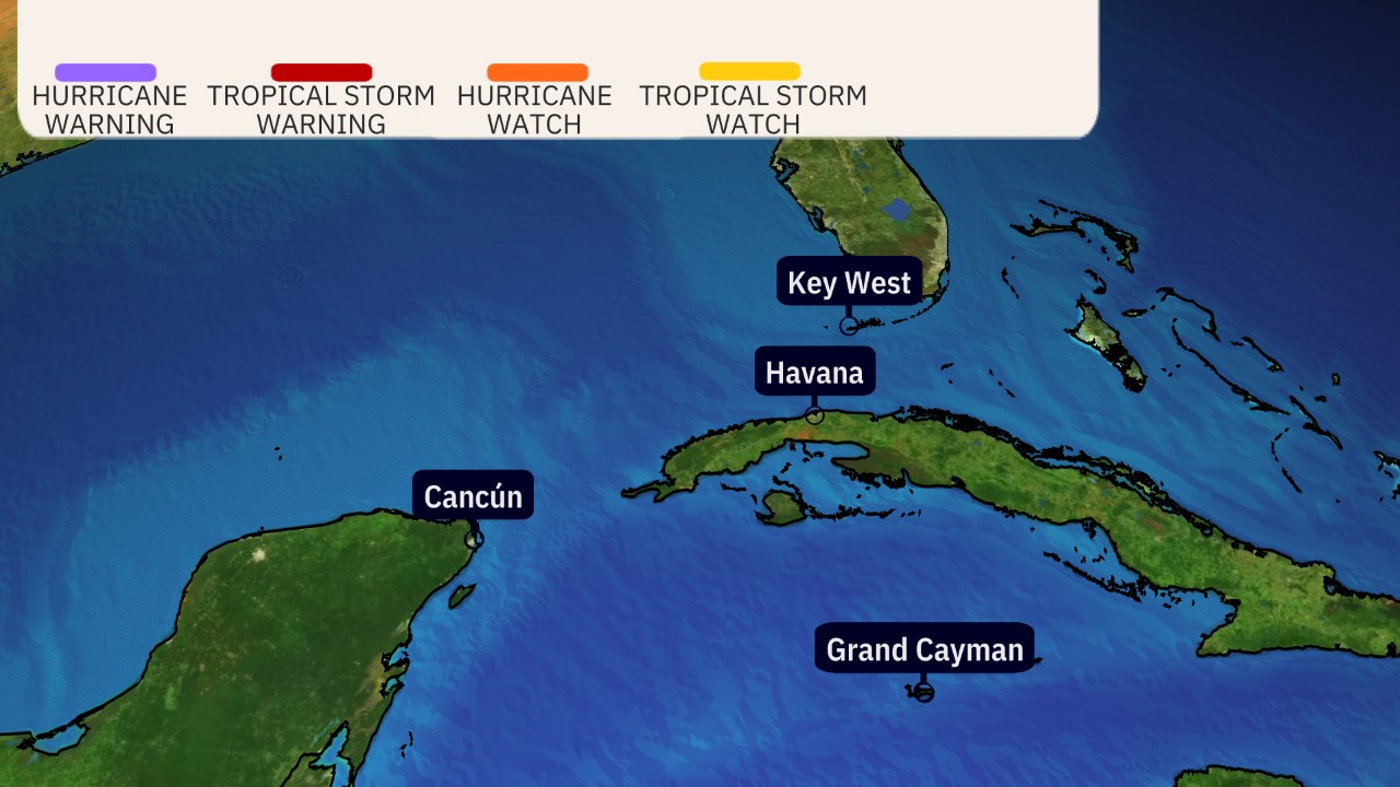
- A hurricane warning is in effect for the northwestern Bahamas, where Dorian will arrive Sunday.
- Dorian is a threat for the Southeast from Florida to North Carolina next week.
- The most likely scenario is a track near the Southeast coast, but that forecast may change.
- Residents along the East Coast should monitor the progress of Dorian closely.
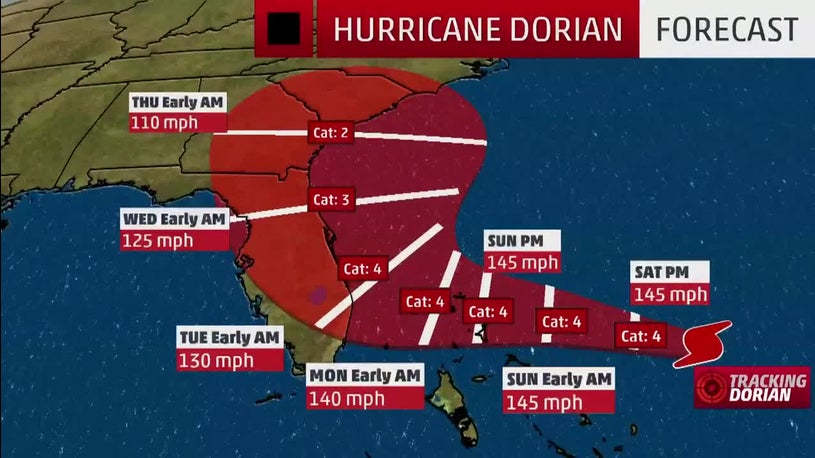
Hurricane Dorian is a powerhouse Category 4 hurricane that is a prolonged danger for parts of the Bahamas, Florida, Georgia, and the Carolinas well into next week.
Dorian's center is about 280 miles east of the northwestern Bahamas. The hurricane is moving toward the west at 10 to 15 mph.
A hurricane warning is in effect for much of the northwestern Bahamas, including Freeport, Grand Bahama, and Nassau, New Providence Island. Andros Islands is in a hurricane watch.
A warning is typically issued 36 hours before the anticipated first occurrence of tropical-storm-force winds (39-plus mph), conditions that make outside preparations difficult or dangerous.
Friday night, a Hurricane Hunter mission found Dorian had become a Category 4 hurricane.
A Saturday morning mission found the hurricane's central pressure had dropped to 944 millibars, a 28 millibar drop in just 24 hours.
Below is the latest on Dorian's timing and what we know about potential forecast impacts right now.
Dorian's Forecast Timing
Saturday: Dorian is expected to slow its forward motion and will likely begin to impact the northwestern Bahamas with tropical storm-force winds by Saturday night.
Sunday: Dorian's hurricane siege will begin in the northwest Bahamas as it continues to slow down. Tropical storm-force winds may begin to arrive in parts of Florida. Large swells should begin to arrive at the coast from North Carolina to Florida.
Monday: Dorian may still be hammering the northwest Bahamas as it crawls slowly. Bands of rain, strong winds may affect parts of Florida. How strong the winds will be depends on how close the center of Dorian is to the Florida coast, which is uncertain at this time.
Tuesday-Thursday: Dorian is expected to move north, then northeast near the coasts of Florida, Georgia, South Carolina and North Carolina. The exact track is very uncertain, ranging from a track far enough offshore to keep hurricane force winds away from land, to a landfall anywhere in this zone.
Friday-Next Saturday: Dorian is then expected to race off the Northeast Seaboard, but could track close enough to bring rain and some wind to the Virginia Tidewater, Nantucket, Martha's Vineyard and Cape Cod, before it heads toward the Canadian Maritimes by next weekend.

Dorian's Track Uncertainty
Uncertainty continues to be high when it comes to exact forecast impacts in the southeastern U.S. However, all interests in the Bahamas, Florida, Georgia and the Carolinas should have their hurricane plans ready and monitor the forecast of Dorian closely.
The myriad of track possibilities range from a Florida landfall and track northward through the Florida Peninsula to a landfall somewhere in the Carolinas to a scrape of the Southeast coast without the center ever moving ashore to a sharper northeast turn well offshore.
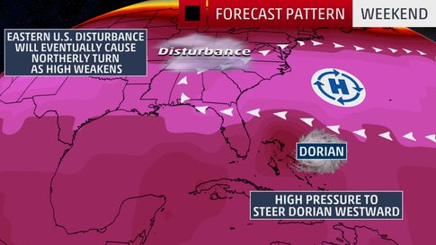
The uncertainty in Dorian's exact track is mainly related to an area of high pressure off the East Coast and when it fizzles.
That Bermuda high is currently steering Dorian toward the west-northwest, but is expected to weaken, leaving Dorian stuck for a day or two, after which it then is expected to turn north, then northeast.
Exactly when it makes those north and northeast turns is critical. If those turns occur later, it's more of a landfall danger for parts of the Southeast coast. If it makes those turns sooner, the threat of a landfall is less, particularly in Florida and Georgia.
Regardless of its exact track, Dorian is likely to be a dangerous hurricane when it nears the U.S. Southeast coast.
Furthermore, as we saw with Hurricane Matthew in 2016, a hurricane doesn't have to make landfall in an area to produce significant impacts.
Dorian's Storm Surge, Wind and Rain Impacts
Bahamas
In the northwestern Bahamas, storm surge may cause water levels to be as much as 10 to 15 feet above normal tide level in areas of onshore winds. Near the coast, that storm surge will be accompanied by large, destructive waves.
Rainfall totals of 10 to 15 inches are expected in the northwestern Bahamas, with isolated amounts up to 20 inches, which may cause flash flooding, according to the National Hurricane Center. The central Bahamas can expect 2 to 4 inches, with isolated totals up to 6 inches.
Southeast U.S.
Larger swells generated by Dorian should begin to arrive along the Southeast coast from North Carolina to eastern Florida Sunday, and will persist for several days. These will be accompanied by dangerous rip currents.
The highest high tides of the year, known as "king tides," are expected this weekend in parts of Florida. King tides occur several times a year, and when combined with a major weather system, the floodwater inundation can be much more significant.
High tides have already caused coastal flooding in northeastern Florida and along the South Carolina coast.
It's too early to know the exact magnitude and location of any impacts from damaging winds, storm surge or flooding rainfall at this time in Florida and the rest of the Southeast.
Destructive winds and life-threatening storm-surge flooding will likely impact parts of the Southeast coast next week, but it's too early to nail down where the worst impacts will be felt, given the track uncertainty mentioned earlier.
The worst wind impacts will occur within the hurricane's eyewall, while the highest storm surge will occur immediately to the east or north of where the center makes landfall, assuming it does at all. Again, it is not possible to determine exactly where these will occur at this time.
In Florida, tropical storm force winds will arrive along the coast well ahead of Dorian's closest pass, making preparations difficult.
Use the times listed below as the time you need have preparations completed.
Coastal sections of the Southeast could 6 to 12 inches (locally, up to 18 inches) of rain, according to the National Hurricane Center. Dorian's slower movement as it nears the coast could cause major flooding.
Should the storm track farther offshore, these rain amounts will be less. And if the track is more inland, this rain footprint would also include areas farther inland.

For now, the entire Florida peninsula and the Southeast coast need to be on high alert into next week.
If you live in an area prone to storm surge, be sure to follow the advice of local officials if evacuations are ordered.
Check back with weather.com for the latest on Hurricane Dorian.
No comments:
Post a Comment