Footnote: My mom and I visited National Weather Service station on Morris Island at Chatham, on Cape Cod, 1970. Arranged the visit myself, by mail, fascinated with meteorology. NWS Station Morris Island/Chatham was located an early gated community at the elbow of Cape Cod. I loved the look on the snooty security schnook when he questioned my mom, driving her trusty old Corvair, as to our business there. With aplomb, I produced the lovely official government letter I received from NWS. And we were in like Flynn. Two meteorologists urged me to become a meteorologist. Cool guys.
Here's Dr. J. Marshall Shepherd's August 30, 2019 article in Forbes:
Why The Pace Of Hurricane Dorian Is So Dangerous

As a meteorologist, I am hoping that people will be making cliche but inaccurate statements that meteorologists are always wrong next week. Hurricane Dorian is a major life-threatening storm, and our best weather models are starting to come into consensus as the time frame to landfall shrinks. I want the models to be wrong but there is nothing that indicates at this time that the will be. Based on the latest information from the models and observations, the state of Florida is facing a potential Category 4 (or higher) hurricane in one of the most populated parts of the state. If you need a reminder of what this type of storm can do, Hurricane Michael (2018) is a devastating and society-changing reminder. The storm blew through rather quickly leaving a path of destruction in Florida, Alabama, and Georgia. Hurricane Dorian will be a slow mover after landfall, and that is an ominous sign. Here's why.
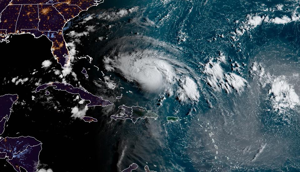
Hurricane Dorian approaching Florida on Friday August 30th, 2019
NOAA/CIRA
The storm has hurricane force winds some 25 miles from the center, and tropical-storm force winds as far as 105 miles from the center. However, the wording that catches my eye is "A slower west-northwestward to westward motion is forecast to begin tonight and continue through the weekend."
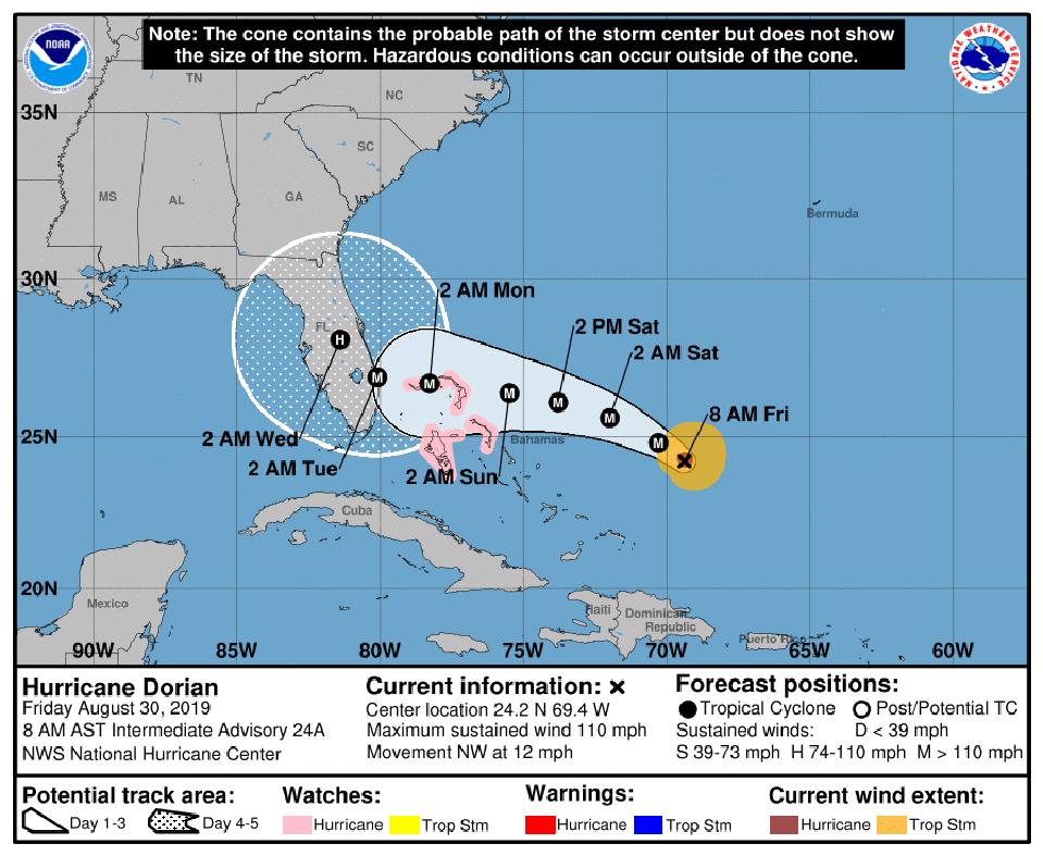
Hurricane Dorian forecast as of Friday morning August 30th, 2019
NOAA NHC
Hurricane Dorian will bring everything that we expect from a major hurricane: wind threats, storm surge, and tornadoes. However, something equally of concern is the potential flood threat. Models project the storm to slow and inch its way up the peninsula in the days following landfall. The figure below shows the position of Hurricane Dorian almost two days after making landfall according to the American GFS model. The European model also has the storm lingering over the peninsula. This pace is a recipe for a dangerous flood event, and the soil moisture in the region is already high because of previous rains this month.
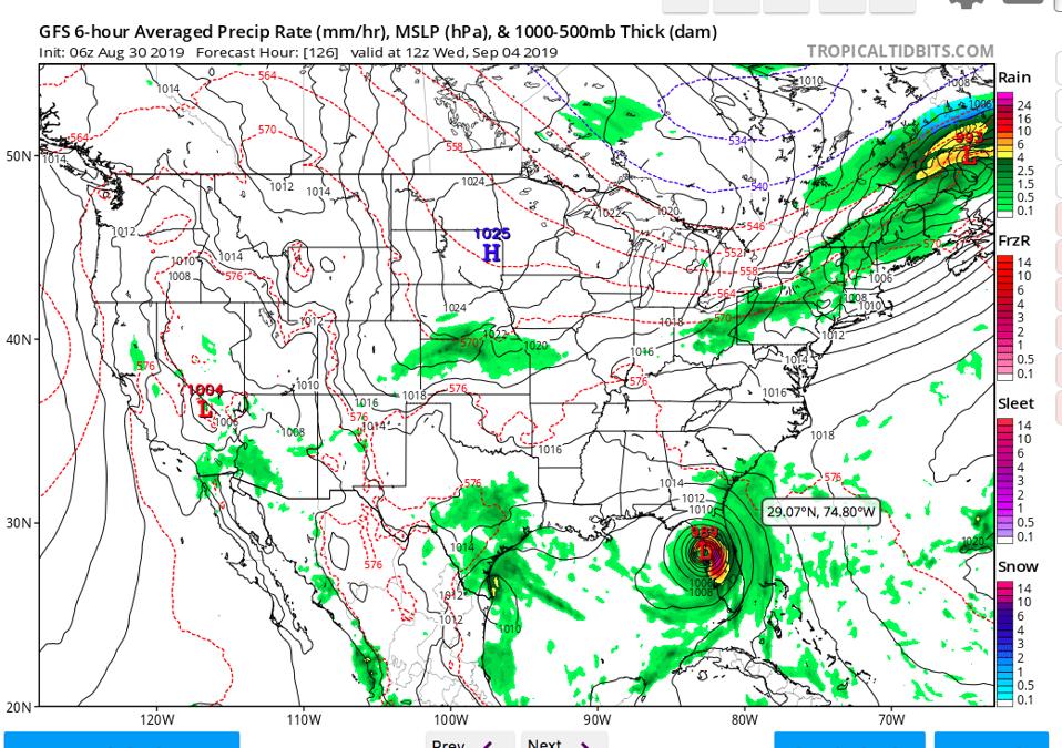
Position of Hurricane Doran on Wednesday morning (September 4th) according to the American GFS model run on Friday morning.
NOAA AND TROPICAL TIDBITS WEBSITE
Hurricane Harvey made landfall as a major storm in Texas in 2017 but then stalled over southeastern Texas. Multiple feet of rainfall fell in the region and forced people from their homes and businesses. In 2018, the Carolinas faced a similar fate with Hurricane Florence. My colleagues and I have worked tirelessly to warn about the dangers of the "water" aspects of these storms because the Saffir-Simpson scale (and thus the media) tends to focus on wind speed. Unfortunately, it appears that Hurricane Dorian will be a storm with multiple hazards. The NOAA Hurricane-WRF (HWRF) projected rainfall swath is presented in the graphic below. There are numbers in excess of 2 feet of rainfall and this could be an underestimation. Wet soil and excessive winds also bring a significant likelihood of power outages. Like Harvey and Florence, we see this possibility well in advance.
If you are anywhere in the Florida Peninsula and coastal regions of Georgia or Carolinas, you need to making plans now for this storm. Landfall is going to be bad enough, and Dorian looks as though it will linger for a while. That's not good.
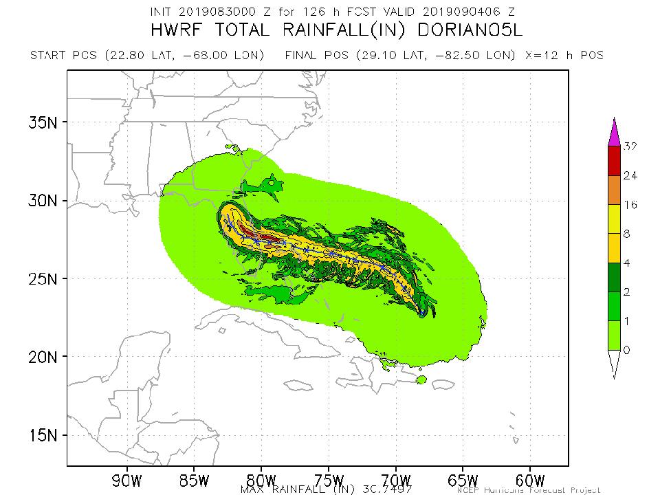
Projected rain swath for Hurricane Dorian
NOAA
No comments:
Post a Comment